Thursday, September 29, 2011

Round Lake: From Methodist Camp Meeting to Modern Village


 The village of Round Lake is located in Saratoga County, NY, between Albany and Saratoga Springs. It stands out in upstate New York for its unusual layout and architecture. I used to live in Saratoga County, and I was always intrigued when I drove through Round Lake. The village consists largely of houses in Victorian style (gingerbread molding, steep gables, front porches, etc.), but many are small cottages, far smaller than most Victorian style houses in the U.S. The houses are located very close together, but with parks and open spaces throughout the settlement. The streets are narrow and laid out in a generally concentric wagon-wheel arrangement around a large wooden assembly hall in the middle. There is an old Victorian style hotel at the edge of town, but the village has few stores or other businesses. Interesting, quaint, and charming, the architecture and layout of Round Lake stands out like a sore thumb in the region around Albany,  New York.
Last spring, as part of an ongoing investigation into semi-urban settlements, I began reading about religious camp meetings. As I looked at their spatial structure, it dawned on me that Round Lake must have originated as one of these summer religious camps. They contain numerous small and insubstantial shelters—usually tents or cabins—arranged around a central circular clearing in the woods where the preaching takes place. Some have a simple elevated open-air stage, and some have more substantial preaching halls. As temporary summer camps, there is no need for a large number of permanent businesses. It seems that in Round Lake, a camp meeting settlement had turned into a permanent village.

Last week my wife and I found ourselves back in the Albany area with a few hours to kill, so we headed over to Round Lake to see whether my interpretation was correct. The first thing we noticed was a historical marker (New York State has great roadside historical markers) that confirmed the village’s origin as a Methodist camp meeting site in the late nineteenth century. We walked around and took some photos (seen in this posting) and talked to some residents. At the Public Library we purchased a history of the town, written in the local history genre. The book is:

Hesson, Mary, David J. Rogowski, and Marianne Comfort
         1998       Round Lake: Little Village in the Grove. Round Lake Publications, Round Lake, NY.
The first meeting, in 1868 (from Hesson et al.)

Round Lake was founded in1868 by the Methodist-Episcopal Church of the Troy Conference. The Rensselaer and Saratoga Railroad stopped at the site, and the first meeting that summer drew 8,000 people! The first preaching, as at many camp meetings, was done from a raised platform built of wood. Attendees stayed in tents. In 1874 Ulysses Grant attended the meeting, and in 1885 the large auditorium was built, with a pipe organ.In 1887, the religious association that had organized the events was changed legally to the Round Lake Association, giving the settlement a broader base than just a summer religious revival camp.By the end of the nineteenth century, secular educational and cultural events had been added to the program, alongside the religious meetings.
The auditorium.
A surviving hotel


Over time, people started building more permanent structures, small wood frame houses in the Victorian style. Wealthier residents built larger houses, and temporary guests stayed in one of several hotels, one of which still survives. Today, the village of Round Lake is a charming place whose residents see themselves as friendly neighbors. Even the librarians, who are not from the village, noted the friendliness of the residents and the open, public aspect of life in the village.
The village, with the lake in the background (from Hesson et al)

The history book mentioned above has some fascinating facts about early Round Lake. In 1878 an entrepreneur built a scale model of the holy land on the shore of the lake, including a large diorama of Jerusalem. Visitors could wander around Mount Lebanon and Galilee, and hear one of the two daily lectures at the park. In 1887 the George West Museum of Art and Archaeology opened in the village, and through good fortune came to house an ancient Egyptian mummy excavated (looted?) in 1881 at Thebes. And we are told that in the winter, people raced horse-drawn buggies on the frozen lake. When I lived in Saratoga County I saw truck races on the ice of the same lake.

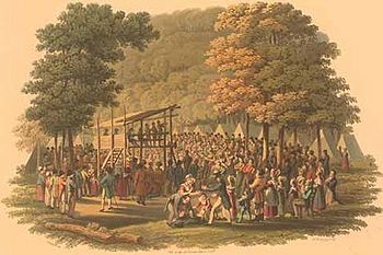
1819 camp meeting (not Round Lake)
For more information on nineteenth century camp meetings, see these sources:

Andrzejewski, Anna Vemer  (2000)  The Gazes of Hierarchy at Religious Camp Meetings, 1850-1925. Perspectives in Vernacular Architecture 8:138-157.

Deviney, Claudia Head  (2002)  From Spirit to Structure: A Study of Georgia's Historic Camp Meeting Grounds. MA thesis , Department of Historic Preservation, University of Georgia.

Duggan, Betty J.  (1995)  Exploring the Archaeological Potential of the Religious Camp Meeting Movement. Tennessee Anthropologist 20(2):138-161.

Moore, William D.  (1997)  "To Hold Communion with Nature and the Spirit-World": New England's Spiritualist Camp Meetings, 1865-1910. Perspectives in Vernacular Architecture 7:230-248.

Weiss, Ellen  (1987)  City in the Words: The Life and Design of an American Camp Meeting on Martha's Vineyard. Oxford University Press, New York.

Sunday, August 28, 2011

Neighborhoods in semi-urban settlements

Pilgrim housing in Mecca
NOTE, added 2015: This paper is now published.

New, rapidly growing places can reveal the patterns and processes of urbanization, sometimes more clearly than traditional cities. I have a group of students working right now on neighborhood organization in what we are calling "semi-urban settlements." This category describes newly-formed residential places, typically with a special purpose, that have rapidly grown into large settlements. If these settlements exhibit neighborhood organization (and it appears that most or all of them do), this would support the notion that neighborhoods are a fundamental component of human settlement.

A second level of analysis focuses on neighborhood dynamics. Are neighborhoods in semi-urban settlements homogeneous or heterogeneous in terms of various social parameters? That is, do they have clustered ethnic or religious groups? Are they formed by the bottom-up actions of residents acting on their own, or are they formed by the top-down actions of authorities who plan and administer these places? And once established, is life in these places more influenced by bottom-up or top-down forces? We hope to find some answers to these questions.

Black Rock City, home of Burnng Man
So what semi-urban places are we including in our sample? Here is our current list (subject to modification):


Periodic settlements:
  • Pilgrimage sites. Where do all those pilgrims stay when they arrive at their destination for several days of worship or relaxation? There is a big literature on pilgrimages as processes, but very litle on the temporary housing in the destination city.
  • Festivals. Burning Man and other annual events bring large numbers of people together for short, intense periods of interaction and activity. Black Rock City, the annual settlement for Burning Man, does have neighborhoods (see my paper on the archaeological study of neighborhoods), but what about other festivals?
  • 19th century camp meeting
  • Camp meetings. Hundreds and sometimes thousands of people were drawn to temporary cities in the woods in nineteenth century America. Did they organize themselves into neighborhoods?

Large-scale contemporary camps:
  • Refugee camps. The creation of spatially separate neighborhoods is part of the design standards for refugee camps, partly for
    Chinese disaster camp
    reasons of logistics and partly to keep hostile ethnic and national groups apart.
  • Disaster camps. Less is known about whether neighborhoods are found in disaster camps or not.
Temporary concentrations of nomads:
RV "neighborhoods" at Quartzsite ?
  • Plains Indian aggregation sites.What happens when nomadic peoples gather in once place for some time? For example, when the Lakota, Cheyenne, and Arapaho gathered at Libble Bighorn to oppose Custer's force, did they arrange themselves into "neighborhoods" by tribal group?
  • Winter RV campsites. RV sites like Quartzsite are the modern equivalent of Plains Indian nomadic aggregation sites. Can these patterns at Quartzsite in Arizona be considered neighborhood-like social units?
Japanese internment camp, Arizona
Practical settlements (see "the city as practical machine")
  • Company towns. Whether 19th-20th century industrial towns (like Pullman in Chicago), or ancient Egyptian workers villages, specialized production-oriented settlements share a number of spatial and social characteristics. Do those characteristics include neighborhood organization?
  • Military camps. As a specialized settlements, established by authorities for some kind of practical task, military camps have some similarity to company towns. Do they have neighborhoods?
  • Internment camps. When large groups of people are forcibly settled in a restricted location that has been built for that purpose, do they form neighborhood-like groups? We will look at the data from Japanese internment camps in the western United States during World War II.
We may also include informal settlements (squatters settlements) and some other settlement types in our project.We think that by investigating neighborhood dynamics at these varied kinds of "semi-urban" places, we can achieve two ends. First, we may illuminate aspects of the social and spatial organization of these settlements. Second, we hope that these cases will help us understand urban neighborhood dynamics in general. Part of the impetus for this study is to explore some of the themes of our recent joint article .

Wednesday, August 17, 2011

Race, ethnicity, social class: Are most urban neighborhoods homogeneous or heterogeneous?

Many modern cities are segregated by race, class, or other parameters, and mixed neighborhoods seem rare. Most people believe that this is not a good situation, for many reasons. Much effort is devoted to trying to reduce the degree of segregation, and there is much research about how to do this. Some writers suggest that in the distant urban past, there were more mixed neighborhoods, and homogeneous neighborhoods are a modern phenomena. Others suggest that traditional cities always had neighborhoods organized by ethnicity or class or occupation. What is the truth here? What do we know about the extent of social clustering in premodern and nonwestern cities? When people who are alike cluster in neighborhoods, is this because they prefer this arrangement and make decisions to bring it about? Or are they forcibly clustered into ghettos, and then prevented from moving by laws and other top-down practices? Or perhaps such patterns arise as byproducts of other actions and decisions? If we study these things for premodern cities, can we derive any lessons for modern urbanism?

These are some of the questions that motivate a research project I am involved in called "Urban organization through the ages: Neighborhoods, open spaces, and urban life." It is part of a series of transdisciplinary research projects at Arizona State University called "Late Lessons from Early History." One of whose goals of this program is to make comparisons between modern and past societies and try to draw lessons for modern society. If you have followed this blog, you will know one of my main purposes here is to explore connections and comparisons between premodern and modern cities. Not only do I write about both modern and ancient cities, but I often compare them or use examples from both categories to make a point.

Our research project has six principle investigators, representing the disciplines of anthropological archaeology (yours truly), sociology, geography, and political science.Our first joint article was published over the summer:

York, Abigail, Michael E. Smith, Benjamin Stanley, Barbara L. Stark, Juliana Novic, Sharon L. Harlan, George L. Cowgill, and Christopher Boone  (2011)   Ethnic and Class-Based Clustering Through the Ages: A Transdisciplinary Approach to Urban Social Patterns. Urban Studies 48(11):2399-2415.

I'd like to be able to say that we have solved the historical puzzles of urban social clustering and segregation, but alas, we have only made a modest contribution. We describe our transdisciplinary and comparative approach to the problem; we discuss a number of drivers or forces that contribute to social clustering at the neighborhood level, and we give a few examples of how these have played out in different historical and geographical settings. We use the term "clustering" because the word "segregation" has considerable baggage in modern parlance, with implications that limit its application to premodern cities. There was ethnic clustering in many premodern cities, for example, but the dynamics were quite different from modern racial segregation. Clustering is a  more neutral term, better for comparative analysis.

One of our conclusions is that there was no single "traditional" form of social clustering. Many writers over the years have assumed that modern western cities developed out of a prior pattern of traditional cities (sometimes traditional means seems to mean medieval, sometimes early modern, sometimes Classical Greece or Rome). If we can understand the traditional situation and how it changed with modernization, this will help us understand modern cities. But there was never any single "traditional" pattern.

Another conclusion is that patterns of social clustering vary greatly, both within and between urban traditions. There is no such thing as a "typical" medieval European urban pattern; some medieval cities had homogeneous neighborhoods, some had mixed neighborhoods. There was no typical "Aztec" pattern or "Islamic" or "Chinese" pattern. Cities varied in their neighborhood organization within cultures or within urban traditions.

And a third conclusion of our paper is that there are many causes or drivers of clustering, and in any given city several of these are likely to play a role. We organize them into four broad categories, each of which has several individual drivers:
  1. Macro-structural forces (capitalism, globalization, etc.)
  2. The state (laws, policies, actions of governments)
  3. Local regimes and institutions (real estate markets, zoning, local elites)
  4. Bottom-up processes (individual choice, chain migration, neighborhood self-regulation).
Our next job is to refine our scheme and apply it to a greater number and range of case studies, with more systematic and in-depth analysis. Stay tuned.

Thursday, July 14, 2011

Spatial order, visual order, and urban planning

Does urbanization cause social breakdown? Are cities places of chaos and crime, where values go out the window? Few people today would answer this question in the positive, although this was social science dogma in the early 20th century (Wirth 1938), until ethnographers like Oscar Lewis (1952) showed that the chaotic cities view was biased and inaccurate.
Shantytown: visual disorder

What about shantytowns and squatters settlements: are these places of chaos and crime and social breakdown? I'll bet that more people would accept this view today than would accept my first question. But like the first question, this viewpoint is a stereotype that is more often inaccurate than correct.  Again, it was ethnographers who went out and lived in these settlements who showed that the sterotypes are wrong (Mangin 1967; Schlyter and Schlyter 1979), but they still persist in the public, among government and civic authorities, and even among scholars.

I think one reason for the endurance of this kind of stereotype is a confusion between visual order and social order. Visual order refers to the kind of regularity in layout that can be perceived by urban residents as well as by those looking at maps or urban photographs. Settlements that are irregular in layout lack visual order. Social order is a deeper and more difficult concept; indeed it has been one of the key issues in sociology and social science for a century (see Hechter and Horne 2003). Briefly, social order refers to the way social groups and societies "hang together" and continue through time in ways that allow many or most people to live "normal" lives.

This diagram shows the way many people think that order works in informal or squatters settlements.
The arrows show causal relationships. In the stereotypical view, social disorder causes visual disorder; therefore when we see visual disorder, we can infer that there is or was social disorder. And central planning leads to visual order.

The second diagram shows an alternative view, more closely aligned with urban reality:
Visual disorder in Lusaka
In this view,  visual disorder is caused not by social disorder, but rather by generative processes. These are the combined actions of people working individually or together in ways that are not controlled or directed by the authorities (see Hakim 1986; 2007). Squatters settlements are a prime example of generative processes at work. People build their own houses, on their own schedule, following their own ideas and values, and this often leads to visual disorder. BUT, generative processes can also lead to visual order! The barriadas of Lima, Peru are a good example. These are squatters settlements, formed through generative processes, but they end up with straight streets and regular lots.If you want to see a technical description of how generative processes can produce visual order, see Erickson and Lloyd-Jones (1997).
Visual order without central planning (Lima)

The big difference between these two views of order is that in the second model, social order and visual order are treated as different things. The ethnographers cited above showed that social order exists within visually disordered settlements. People help their neighbors, they watch out for one another, they aren't criminals, they have jobs and lead normal lives (if poverty can be considered "normal," that is). And conversely, social disorder can exist in well-planned, visually ordered settlements; think about crime or anomie in nice planned neighborhoods

The only thing these two models share is the notion that central planning leads to visual order. But don't think that straight streets and checkerboard layouts represent the only kind of urban visual order (Smith 2007). The wide urban world contains many types of visual order, and many kinds of social order. But one does not produce the other. It's time to abandon those stereotypes.

References:

Erickson, B. and T. Lloyd-Jones
1997    Experiments with Settlement Aggregation Models. Environment and Planning B: Planning and Design 24:903-928.

Hakim, Besim S.
1986    Arab-Islamic Cities: Building and Planning Principles. Routledge, London.

2007    Generative Processes for Revitalizing Historic Towns or Heritage Districts. Urban Design International 12:87-99.

Hechter, Michael and Christine Horne (editors)
2003    Theories of Social Order: A Reader. Stanford University Press, Stanford.

Lewis, Oscar
1952    Urbanization Without Breakdown: A Case Study. Scientific Monthly 75:31-41.

Mangin, William
1967    Latin American Squatter Settlements: A Problem and a Solution. Latin American Research Review 2(3):65-98.

Schlyter, Ann and Thomas Schlyter
1979    George: The Development of a Squatter Settlement in Lusaka, Zambia. Swedish National Institute for Building Research, Lund.

Smith, Michael E.2007    Form and Meaning in the Earliest Cities: A New Approach to Ancient Urban Planning. Journal of Planning History 6(1):3-47.

Wirth, Louis
1938    Urbanism as a Way of Life. American Journal of Sociology 44:1-24.

Sunday, July 10, 2011

Why build a city on a mountain?

The Aztec-period city of Calixtlahuaca covered this mountain

Here is a photo of Cerro Tenismo, the volcanic mountain that was covered by the Aztec-period city of Calixtlahuaca. I've directed an archaeological project at this site for several years, and I am still puzzling about why the founders of this city decided to build on a mountain. Some of this post is taken from an older post (of the same name) on the Calixtlahuaca Project blog.

Calixtlahuaca  covered most of the top and sides of this mountain, plus another hilly area to the southeast (to the left, in this photo). The several thousand inhabitants built their houses on stone terraces, which were also farmed with maize and maguey plants. The city was founded ca. AD 1100, and was occupied until the first couple of decades after the Spanish conquest of Mexico in 1521.

The first place to look for comparative insights into Calixtlahuaca's hilltop location is to other Mesoamerican cities built on mountains. Monte Alban and Xochicalco are two of the largest and best known examples, both powerful capitals during their day. It has long been clear to archaeologists that these cities were built where they were for reasons of defense. Images of mountaintop cities in Mesoamerican pictorial codices (see my entry on the Calixtlahuaca blog on these) tend to show battles and defensive walls. But for several reasons, we don't think that defense was a major factor in the layout of Calixtlahuaca:
  1. We did not find any defensive walls or ditches.
  2. The largest civic buildings were not built in a protected location.
view down the hill from excavation unit 323
The second factor is quite striking. The royal palace was at the base of the hill, completely unprotected, as was a large unexcavated platform (Sructure 16). The two largest temples, structure 3 (circular temple, dedicated to the wind god Ehecatl) and structure 4 (rectangular temple, dedicated to the rain god Tlaloc) were built part-way up the hill, but closer to the base. Again, these were relatively unprotected. When defense is an issue, the main civic buildings are almost always built at the top of the mountain or hill (again, think Monte Alban or Xochicalco, or any one of innumerable hilltop cities in the Old World).

Well, what is so surprising about building a city on a mountain if defense was NOT a major consideration? The answer is the effort required to build the site. Every house that was built had to be accompanied by the construction (and constant maintenance) of stone terraces. Temples 3 and 4 required massive platforms and large excavations into the hillside to build level areas for these temples and their groups.

There is much flat land in the surrounding Toluca Valley, so it would not have been hard to find a level location for the city. This was rich farmland, and we don't think populations were so high that people couldn't build their settlements on the plain. One factor that comes to mind about Calixtlahuaca's mountain location is show: the city would have looked very impressive to visitors approaching from the north, with its north flank covered with houses and large temples. But how can such a hypothesis be tested?
Ephesus

In order to gain additional perspective on Calixtlahuaca's location, I have been looking for other ancient cities around the world whose residential zones were built on mountainsides, with the civic architecture at the base of the hill. Ephesus (the Roman occupation) is one example (see photo), and I am looking for others. If you have suggestions—whether examples of similar premodern cities, or ideas about how to interpret Calixtlahuaca's location—let me know!

Friday, July 1, 2011

Tent city in Sana'a, Yemen

The tent city at night
Protesters in Sana'a, the capital of Yemen, have set up a tent city where they organize their protests against their repressive president. An article in Spiegel Online International starts,
" What started as a sit-in has turned into an experment in democratic society. In the last four months, between 3,000 and 4,000 tents have been pitched in the streets of the university district in the Yemeni capital Sana'a. The tent city includes pharmacies and a makeshift hospital, four daily newspapers, auditoriums, a garden and hastily constructed cement memorials for the martyrs.

Protesters in a tent

It is a city of citizens, a taste of what Yemen could become, a concrete utopia made of tarps, pallets, satellite dishes and a hodgepodge of power cables the protesters have audaciously connected to the grid in the ancient city. There is a "diplomats' tent" and a tent for actors; there are daily poetry readings and demonstrations; there is even a prison."
This great photo is from: http://twitpic.com/43px3h. (check out the credit line: "©2011, The New Yemen, Free to be used during the revolution." The photo is by Abdulrahman H. Jaber.

This kind of temporary settlement joins the other examples of "temporary cities" that I blogged about a while ago. These settlements usually attract attention for their main functions (protest and contentious politics in Sana'a, art festival at Burning Man, etc.). But I think we should pay more attention to their urban features, which may have much to teach us about cities and how people form and live in cities.

Media tent for the protesters
I have been interested in traditional Sana'a for some time now. It is a distinctive variation on Arabian/Islamic urbanism, particularly well studied by scholars. Its neighborhoods are fascinating, and the presence of food-producing areas within the midst of high-rise apartment buildings is a surprising feature that may have lessons for urban sustainability and livability elsewhere. You have to cover several languages to resesarch traditional Sana'a, though. For some great photos, go to photographer Abdulrahman H. Jaber's website. and click on "Old City of Sana'a." You'll see some outstanding photos.

References:

Sana'a gardens
Barcelo, Miquel (editor)  (2004)  Les jardins dans la vieille ville de Sanaa, Yémen. Université Autonome de Barcelone, Barcelona.

Bonnenfant, Paul (editor)  (1995)  Sanaa: architecture domestique et société. Editions CNRS, Paris.

Kopp, Horst and Eugen Wirth  (1990)  Beiträge zur Stadtgeographie von Sana'a. Beihefte zum u*binger Atlas des Vorderen Orients. Reihe B, Geisteswissenschaften. L. Reichert, Wiesbaden.

Kopp, Horst and Eugen Wirth  (1994)  Sana'a: développement et organisation de l’espace d’une ville arabe. Translated by Blandine Blukacz-Louisfert and François Blukacz. IREMAM and CFEY, Aix-en-Provence and Sanaa.

Lewcock, Ronald B.  (1986)  The Old Walled City of San'a'. UNESCO, Paris.

Serjeant, Robert B. and Ronald Lewcock (editors)  (1983)  San'a: An Arabian Islamic City. World of Islam Festeival Trust, London.

*** Thanks to Nate Berg''s tweet for the Spiegel story on this!!! Maybe Twitter is useful after all.....
(Nate Berg's website)

Friday, June 10, 2011

Cahokia, Native American Urban Center on the Mississippi

 The Mississippian center of Cahokia, in Illinois across the Mississippi from St. Louis, is one of the great cities of the ancient world. I have a special reason for discussing Cahokia now: there is a challenge taking place to raise funds to help preserve the site. This is the "This Place Matters Community Challenge,"  a contest presented by the National Trust for Historic Preservation.  The top three sites will receive a cash prize to help preserve their site.  The challenge hopes to "highlight the important role that historic buildings and properties play in preserving our national heritage as well as in preserving our environment." While I don't want to belittle the other historical structures and districts that are participating, in my mind none of them is anywhere close to Cahokia in its world importance. Please go to the website and cast your vote for Cahokia. And here are some reasons why you should do that.

Monk's mound, home of the chief

  • Of all the known traditions of ancient urbanism around the world, the Mississippian cities are among the most poorly known. Their builders used earth instead of stone for their monuments, many of which have not survived well. There is a long-standing bias against recognizing the achievements of Native Americans and their ancestors, part of which is a common attitude that they built only ceremonial centers, not true cities. Yet Cahokia and many other Mississippian centers can easily be classified as "urban."
  • Arrow points from elite burials
  • If one takes the demographic approach to defining urbanism, the 20,000 to 30,000 inhabitants of Cahokia and their economic and political complexity classify it as a city. And if one takes the functional definition of urbanism, the political, religious, and economic activities at the city served larger hinterlands, thus putting Cahokia into the category of a city. (See my earlier discussion of definitions of urbanism here).

  • The chiefs or kings of Cahokia were powerful rulers. The size of their main palace, Monk's Mound is evidence of this, and rich burials point to an elite class as well (see the photo of hundreds of  
    Excavation of the palisade 
    arrow points from elite burial offerings). Warfare was common during Mississippian times, and a large palisade was built around the center of the city (photo).
  •  


  • Stone drills and shell ornaments
    This was a complex economy. Imports from all over eastern North America have been excavated at Cahokia, and goods and styles from the city were found hundreds of miles away. Craft production was both an economic force and an aesthetic activity. The photo shows hundreds of chipped stone drills, used to manufacture beads and other ornaments from stone.
  • The Birger figurine
  • The people of Cahokia had a rich religious life, with many family-level and city-level ceremonies. One important find was this stone figure of a woman cultivating crops, with a squash vine running up her back. It is known as the "Birger figurine" after the owner of the property where it wasexcavated. It is from the "BBB Motors site" just east of Cahokia proper, a village associated with Cahokia. This is a special site to me, since this is where I had my archaeological fieldschool with Chuck Bareis back in the 1970s. We didn't find the figurine, though. We excavated a bunch of test pits, and later the plow zone was stripped off with heavy machinery (and they found the figurine).
  • The "woodhenge"
     
  • Another type of ceremony focused on astronomical observations. Cahokia's priest-scientists built the "woodhenge", a circular arrangement of poles used for sighting sunrise and sunset on important annual dates. Like so many intellectual activities in ancient cultures, this was part science, part ritual, and part politics.


    From the perspective of the Wide Urban World, Cahokia presents an important addition to the roster of urban forms around the world. It was a city by any definition, but a distinctive city from a tradition of urbanism that is not widely known or appreciated. The site needs better preservation today, and you can help by following the links to the contest.


    Finally, here is what the Cahokia Mounds people have to say about why you should vote for Cahokia:
    This place matters to our community because it is a place that preserves the cultural and historical remains of this 1000 year-old economic, residential, and religious center of Mississippian culture. Cahokia was the center of a large metropolitan complex that included four other major mound centers, a number of single-mound local centers, and numerous small villages, hamlets and farmsteads.  Evidence of Cahokia's influence has been found as far away as Minnesota, Florida, Oklahoma, and Georgia.  The state property preserves the central portion of the site, but about 1/3 of the original city lies outside of this boundary and is threatened by contemporary activities.  Funds are needed to acquire and preserve these threatened areas.   Our community stands to lose much information about America's first city if 1/3 of the site is destroyed.  Not only does this site preserve and interpret Mississippian culture for our community, the nation, and the world, but it also fosters a sense of preservation and prehistoric appreciation, educates on the science of archaeology, and the achievements of ancient Native Americans. This place matters to all Americans, and is a pivotal point in American History that deserves to be shared.
    Again, click here for the link to the contest

    To read more about Cahokia, try some of these works:

    Emerson, Thomas E.
    1997    Cahokia and the Archaeology of Power. University of Alabama Press, Tuscaloosa.

    Fowler, Melvin L.
    1989    The Cahokia Atlas: A Historical Atlas of Cahokia Archaeology. Studies in Illinois Archaeology. Illinois Historical Preservation Agency, Springfield.

    Iseminger, William R.
    1996    Mighty Cahokia. Archaeology 49(3):30-37.

    Milner, George R.
    1998    The Cahokia Chiefdom. Smithsonian Institution Press, Washington, DC.

    Pauketat, Timothy R.
    2009    Cahokia: Ancient America's Great City on the Mississippi. Viking, New York.

    Young, Biloine Whiting and Melvin L. Fowler
    2000    Cahokia: The Great Native American Metropolis. University of Illinois Press, Urbana.

    Also, check out the website for Cahokia Mounds State Historic Site.
    _________________________

    I want to thank Elyse Butler, a Graduate Research Assistant at Cahokia Mounds, for bringing the contest to my attention, and for supplying the text quoted above.