Showing posts with label comparative. Show all posts

Friday, December 14, 2012

How to compare cities, using digital methods


 I am writing from the city of Leeds in Yorkshire, where a very nice conference on comparative urbanism just finished up. This is a quick post about the session, and maybe I will write something in more detail at a later time. The session was called “ACUMEN: Assembly for Comparative Urbanism and the Material Environment." with the subtitle: “Digital methodologies for social research for processes of urban landscape development.” The conference was the brainchild of Benjamin Vis, an archaeologist who is now in the Ph.D. program in Geography at the University of Leeds. It was held at Haley’s Hotel in Leeds, a comfortable place to talk about urbanism with a bunch of fascinating people (although they aren't going to win any awards for their internet service - I may or may not get this thing posted before I leave town!). There is some information at the pre-conference website.

The ACUMEN conference brought together people working on various approaches to comparative urbanism and using various current methods, in particular historical/archaeological GIS analysis. There were geographers, historians, archaeologists, architects, and some folks difficult to classify. In addition to presentations by established scholars, the conference include a “PechaKucha,” an event that was new to me. A group of people, mostly students, gave very brief presentations of their research, limited to 20 slides and six minutes.

I gave the opening talk, and a summing-up at the end. Benjamin called me the conference “Ambassador,” but I am still not sure what that meant. It was fascinating to hear about a bunch of creative and important urban research projects. My approach to comparative urbanism, which should be clear if you have followed this blog, has been to start with a theme that cuts across many periods and regions, especially ancient and modern cities. Themes I’ve written about (here and in articles) include informal settlements, urban sustainability, urban sprawl, neighborhoods, and gated communities. So far, my comparisons have not been done in great detail, except perhaps for the theme of neighborhoods.

Most of the participants in the ACUMEN conference used one or both of two alternative approaches to analysis and comparison. The first is methodological. GIS analysis is rapidly becoming the standard method in research on urban form (and other topics) in archaeology, geography, and history. We heard about some great urban-GIS analyses, particularly the historical mapping of Paris by Eric Grasso and colleagues, and studies of medieval British towns by Keith Lilley (I apologize for this hasty posting, without links; I will try to get them done, but it may have to wait till I am back in Arizona). GIS is a method to provide a standardization of data for comparing cities.

The second method to comparison discussed at this conference is theory- or approach-driven. The two main examples here were space syntax and urban morphology. Space syntax, a method of analyzing the uses of and access to spaces in buildings and cities, has become increasingly popular in some archaeological traditions. It is not a universal method, because its applications rely on complex room arrangements within buildings, or street patterns in cities. In my own case, Aztec houses have one room and Aztec cities do not have streets. But for the western urban tradition (plus a few examples from other traditions), space syntax is very useful. Sam Griffiths, a space syntax expert at the University College London (center of the space syntax movement), gave an interesting talk on the methods, its uses, and its limitations. A number of the other participants are using, or have used, space syntax previously. (links will be provided……).

Urban morphology is more of a method or approach than a theory. See the journal Urban Morphology for examples. This approach fits well with GIS (as in Keith Lilley’s work) and with space syntax. While only a couple of the participants work within the urban morphology approach, most of the work featured at the conference focused on urban morphology or form in a broader sense.

This was a great session, and we all left with new ideas and inspiration to try to keep the cross-disciplinary dialogue going somehow. Benjamin Vis will probably be setting up a website for ACUMEN before long, and I will talk more about this in the future.

I also got to spend part of a day in York, looking at Roman, Viking, and medieval remains. And it was great sampling the local ales.

Monday, April 30, 2012

Archaeology as a social science

Excavated house at Calixtlahuaca
I haven't been posting very often lately because I have been on sabbatical leave, working hard to finish a book manuscript: Aztec Communities and Households: Archaeologists Discover a Sustainable Way of Life. I have gotten a draft finished, and now I am looking for a literary agent so that I can attract a publisher to provide a broad, nonspecialist, readership.

Today this paper was posted online by the Proceedings of the National Academy of Sciences:

Smith, Michael E., Gary M. Feinman, Robert D. Drennan, Timothy Earle, and Ian Morris
    2012    Archaeology as a Social Science. Proceedings of the National Academy of Sciences 109:(published online).

I have posted the paper here.  ||  There is some ASU publicity about the paper here.

We argue that because of recent fieldwork and methodological advances, archaeology is now starting to contribute knowledge to the social sciences beyond anthropology. We illustrate this point with several examples:
  • Early village society
  • Cities and urban planning
  • States and markets in deep history
  • Standards of living.

 These are topics covered to some extent by various social sciences (economics, political science, historical sociology, urban studies), and for each, archaeologists now have data that relate to current concerns in those fields.


 A brief section on urban planning includes the figure shown above to illustrate the point that cities with unplanned neighborhoods (e.g., the Yoruba city Ado Ekiti) were much more common in the ancient past than fully-planned orthogonal cities (e.g., the Greek city Priene), despite the common assumption that ancient cities were mostly like the Greek example.

This is a topic I've blogged about before, for example:

Spatial order, visual order, and urban planning

Are shantytowns a normal form of urban residence?

If you want a copy of the PNAS paper, CLICK HERE.

Thursday, October 27, 2011

Did premodern cities have "urban issues"?

The basic premise of this blog is that cities and urbanism have been around for thousands of years, and that it is interesting and useful to take a broad perspective on these things. The "Wide Urban World" is the realm of cities from ancient Mesopotamia to the present. Consideration of premodern cities can provide insights into modern urban issues, and research on contemporary cities can help historians and archaeologists understand past cities. And consideration of both modern and past cities will allow us to understand the nature and variation of urbanism much more fully than a narrow focus on a single time period or place. Beyond this blog, my colleagues and I have made this point in a number of publications (see the list at the bottom).

There is an alternative understanding of the meaning of the term "urban," however, that is much more narrowly conceived. To some, "urban issues" are issues of contemporary cities (and perhaps their predecessors over a century or so). Either past cities did not have "urban issues," or else their "urban issues" are irrelevant to modern concerns, not worth considering. This is the viewpoint of the well-known policy institution, the Urban Institute, which features "nonpartisan economic and social policy research." This kind of "present-only" perspective on urbanism can be called "presentism." For critiques, see any of the papers below (particulalry Harris & Smith 2011).

Now there is another presentist institution, the new "Urban Portal" of the University of Chicago, billed as "a gateway to the latest in urban social science." I looked around the site and its resources, and much of it looks interesting and important. But I found no explicit acknowledgement that history or comparison are considered important for urban social science. Well, that is certainly not my view of the topic. Let me re-write their "about" section in a more accurate manner:

"The Urban Portal is an online hub designed to provide experts and non-experts easy access to current research and resources on CONTEMPORARY urban issues IN THE UNITED STATES. The Portal is a core project of the University of Chicago Urban Network, an emerging community of scholars and others that aims to spur innovation in the study of MODERN urban processes and to encourage interdisciplinary discourse in urban research, theory, and policy THAT EXCLUDES HISTORICAL OR COMPARATIVE PERSPECTIVES."

If you'd like to see a more formal scholarly argument for the kind of broad approach to urban studies I advocate, look at this White Paper some of us submitted to the program "Future Research in the Social, Behavioral and Economic Sciences" at the National Science Foundation, or look around our website.


REFERENCES:
 
Briggs, Xavier de Souza
2004    Civilization in Color: The Multicultural City in Three Millennia. City and Community 3:311-342.

Fletcher, Roland
2009    Low-Density, Agrarian-Based Urbanism: A Comparative View. Insights (University of Durham) 2:article 4.

Grant, Jill
2001    The Dark Side of the Grid: Power and Urban Design. Planning Perspectives 16:219-241.

2004    Sustainable Urbanism in Historical Perspective. In Towards Sustainable Cities: East Asian, North American and European Perspectives on Managing Urban Regions, edited by André Sorensen, Peter J. Marcutullio, and Jill Grant, pp. 24-37. Ashgate, Burlington, VT.

Hakim, Besim S.
2007    Generative Processes for Revitalizing Historic Towns or Heritage Districts. Urban Design International 12:87-99.


Harris, Richard and Michael E. Smith
2011    The History in Urban Studies: A Comment. Journal of Urban Affairs 33(1):99-105.

Smith, Michael E.
2009    Editorial: Just How Comparative is Comparative Urban Geography?: A Perspective from Archaeology. Urban Geography 30:113-117.

2010    Sprawl, Squatters, and Sustainable Cities: Can Archaeological Data Shed Light on Modern Urban Issues? Cambridge Archaeological Journal 20:229-253.

York, Abigail, Michael E. Smith, Benjamin Stanley, Barbara L. Stark, Juliana Novic, Sharon L. Harlan, George L. Cowgill, and Christopher Boone
2011    Ethnic and Class-Based Clustering Through the Ages: A Transdisciplinary Approach to Urban Social Patterns. Urban Studies 48(11):2399-2415.

Thursday, May 26, 2011

Why are premodern cities important today?

Medieval street life
Sociology without history resembles a Hollywood set: great scenes, sometimes brilliantly painted, with nothing and nobody behind them. Seen only as the science of the present or — worse yet — of the timeless, sociology misses its vocation to fix causation in time. It thereby vitiates its vital influence on historical thinking, its influence as the study of social mechanisms operating continuously in specific times and places.
-- Charles Tilly (2008:120)

Substitute "urban studies" for sociology, and this quote from Charles Tilly nicely describes one of the reasons that premodern cities are important if we are to understanding cities and urbanism today, throughout history, and in the future. (I use the term "premodern" to include ancient cities around the world, European cities prior to the industrial revolution and world cities prior to the expansion of European imperialism).

I see at least four reasons for the continuing importance of premodern cities for understanding modern and more general processes of urbanization. Two are examples of what I call the "urban trajectory" argument: trajectories of urban change over the decades and even over centuries show us how cities work, and how they respond to and shape developments in their social contexts. The other two reasons are versions of the "sample size" argument: adding premodern cities to the list of modern cities gives us a much larger sample, which helps us in both understanding and planning/managing cities.

Kilwa (Swahili)
 1. Urban trajectory argument, A: the long perspective

The quote from Winston Churchill that I use in the description of this blog (see the right-hand column) justifies this argument: "The farther back we look, the farther ahead we can see." Archaeological data on ancient cities describe trajectories of urban expansion and retraction over long periods. Why were some cities successful for many centuries while others rose and fell within a decade or two? Why did cities initially develop in several parts of the world independently? Big urban questions like these can only be answered with the long time perspective of archaeology and history.

2. Urban trajectory argument, B: the short perspective

To understand the nature or structure of cities (or society) today, we need to know how they developed in recent decades and years. The urban past created the urban present, an argument Richard Harris has illustrated in several works (Harris and Lewis 1998; Harris and Smith 2011). Sometimes cities develop in ways that leave them little opportunity to easily change (this is called path dependence), and in other cases urban development is more flexible, allowing more options today and in the future. This second trajectory argument also applies in the past. Europeans constructed colonial cities in the New World, but those of Latin America differed from those in North America. Part of the reason for these differences is the existence of vibrant indigenous urban traditions in many parts of Latin America, but not in North America. Indigenous trajectories influenced subsequent urban development.

Babylon
3. Sample size argument A:  a broader base for generalization and explanation

Many observers are struck by regularities in city form and process. All cities have neighborhoods. Nearly all cities have a civic center with prominent public buildings. Many cities have higher population densities than smaller settlements in their society. To fully appreciate the patterns of similarity and difference among cities, scholars need to draw on as large a sample of cities as possible. Most works on urban history and comparative urbanism focus wholly on the western urban tradition, which obviously biases our picture of cities (and many other social phenomena). But cities in other eras may or may not have resembled European cities. Cities in pre-European Africa and in Mesoamerica were much more dispersed than western cities, yet they shared the same urban functions (administrative roles, economic activities, religious significance, etc.). We will never be able to understand the phenomenon of urbanism unless we consider the widest possible range of cities.

4. Sample size argument, B: more choices for planners and managers to draw on

Urban growth and its affects on society and the environment is surely one of the major social problems facing us today. How can we cope with persistent poverty, crime, and overcrowding in many cities? How can we reduce the ecological footprint or the carbon footprint of our growing cities to make them more environmentally sustainable? Planners, politicians, managers (and scholars) who consider these issues need ideas. If they consider a wider range of cities and urban traditions, they may be able to come up with better solutions to today's urban issues. I am not arguing that a detailed knowledge of, say, Teotihuacan, will by itself illuminate the problems of a city like Phoenix today. But if planners are familiar with Teotihuacan, Machu Picchu, Ur, Timbuktoo, Kilwa, and other premodern cities, this may help stimulate creative thinking on how we might improve cities today.

Teotenango, Mexico. The ancient ruins are on a cliff above the modern town

References

Harris, Richard and Robert Lewis
1998    How the Past Matters: North American Cities in the Twentieth Century. Journal of Urban Affairs 20:159-174.

Harris, Richard and Michael E. Smith
2011    The History in Urban Studies: A Comment. Journal of Urban Affairs 33(1):99-105.

Smith, Michael E.
2010    Sprawl, Squatters, and Sustainable Cities: Can Archaeological Data Shed Light on Modern Urban Issues? Cambridge Archaeological Journal 20:229-253.

Tilly, Charles
2008    Explaining Social Processes. Paradigm Publishers, Boulder, CO.

Saturday, April 30, 2011

The Ancient History of Gated Communities

Fig 1 - Modern gated community
Gated communities are a hot topic of research and discussion in urban studies. As summarized in a recent encyclopedia entry:
 Although gated communities are eulogized by residents, developers, and real estate agents for providing safe family spaces and secure financial investments, they have received a largely negative press from academics and the media, who perceive them as private fortresses that destroy the vibrancy of the city through their exclusivity. (Lemanski 2008)
The dominant view -- both scholarly and popular -- emphasizes security and fear. People are shutting themselves away in gated communities to keep out crime and undesirables. The spread of gated communities is said to produce alienation and anomie among residents, and a socially divided or segregated urban landscape (Blakely and Sneider 1997; Low 2001). Some research, however, challenges the security/fear interpretation of modern gated communities. Andrew Kirby and colleagues (Kirby et al. 2006), for example, report that in a sample of Phoenix gated communities, "residents are not alienated" (p.29), and the communities are not responses to a "culture of fear."
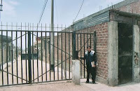
Fig 2- Informal neighborhood gate, Lima

The fear/security factor may, in fact, be more prominent in gated communities in poor neighborhoods of cities in the developing world than in modern U.S. or European cities. In Peru, enclosed areas are being established long after initial construction, by the residents themselves. Jörg Plöger (2006) studied neighborhoods in Lima, Peru, and found that most neighborhoods are "enclosed" or sealed off (with barriers and fences) by their residents for reasons of security (figure 2). These gates are installed not by developers or municipal authorities, but by the residents; they are informal, not formal, urban features. And even Dharavi, the Mumbai slum (of Slumdog Millionaire fame) where people are living in extremely close quarters, is the setting for many fenced-off residential zones. Jan Nijman (2010) explores how Dharavi challenges a number of standard notions in urban studies, a field whose models are based overwhelmingly on modern western cities.

Fig. 3- Chinese walled compound

These studies of the developing world are important for establishing a broader comparative perspective for gated communities. When we consider the past, the diversity of forms and meanings of gated communities increases even more. It turns out that gated communities have been common in Chinese cities for more than a millennium (Xu and Yang 2009), and they have been prominent in Mexico from the time of Spanish conquest until the present (Scheinbaum 2008). Figure 3 shows a traditional Chinese walled compound (i.e., a gated community). Interestingly, these features  resemble Inka walled compounds (called kancha) in Peru (figure 4). There is no historical connection at all between the Chinese and Inka examples; these are independent adaptations to what were probably similar urban forces and conditions. My guess would attribute this similarity in form to the importance of kinship and lineage in Chinese and Inka society. Several generations of families live together,
Fig 4 - Inka Kancha
 and the compound wall served as a visible marker of the close-knit social unit.


As in most premodern cities, the Chinese compounds were probably designed by their residents, and built either by the residents or by builders contracted by the residents. We know less about the construction of Inka compounds. The Inka state was strongly bureaucratic, and officials supervised and carried out many activities that were left to individual families in most early societies. Maps of Inka settlements show that these kancha units are highly standardized, perhaps because of central planning (Hyslop 1990).

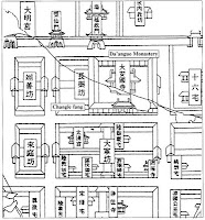
Fig 5- Walled compounds in Chang'an
In some ancient cities, there is clear evidence for state planning in the construction of walled residential compounds. In Tang period Chang'an China, more than a millennium ago, the more than one million residents lived in walled-in neighborhoods. Gates closed off these neighborhoods at night, and guards made sure people stayed in their walled compounds and off the streets. A stone map from A.D. 1080 (figure 5) shows these ancient gated communities. In the following Song period, the state's power declined with a dramatic rise in commerce. In place of two enclosed markets, shops and stalls proliferated along the streets, gates were no longer guarded, and a real urban street life was generated. In this case, the gated communities were part of a state policy of control of the population, and when the policies changed to allow more freedom and self-determination, the gates came down (Heng 1999)

Fig 6- Old neighborhood gate, Jerusalem
Just the opposite process occurred in the Islamic cities of the Ottoman period in the Near East -- the neighborhood walls came down not from a loosening of state control, but from the imposition of strong control. These traditional cities had enclosed neighborhoods whose walls and gates were built by the residents (figure 6) to protect their neighborhood from outsiders; municipal and state authorities did not concern themselves with regulating life at the neighborhood or household level. But when these cities were conquered by European empires, one of the first tasks of the imperial overlords was to tear down the neighborhood gates. The new rulers were worried that people might be planning resistance in these closed neighborhoods, and the streets were opened up so that officials could begin to see what was going on in these areas (Abu-Lughod 1987).


Fig 7 - Hohokam walled compound
If there is this much variation in the social contexts of gated communities in premodern (and modern) cities, how can archaeologists begin to interpret ancient gated communities at sites where there are no written records? The Hohohkam of southern Arizona, in the final period prior to collapse and abandonment of their towns (ca 12th-15th centuries), started building walls around their neighborhoods (figure 7). Previously, their houses had been built in groups or clusters, with without walls. What does this signal? Or consider the Iron Age oppida towns in Europe (these are the towns defeated by Julius Caesar in his conquest of Gaul). Some of them had gated communities (figure 8). The walls in this reconstruction are not very high. Do they signal social exclusion, or perhaps just a way to keep the farm animals from wandering?
Fig 8 - Iron Age walled compound

These comparisons have intrigued me for a number of years. What is needed is a comprehensive comparative study of walled compounds / gated communities in the premodern world. Synthetic studies like Grant and Mittelstaedt (2004) are a good place to start. Perhaps we can figure out some of the social parameters of these features, and allow archaeologists to link the spatial layouts to social processes. Or perhaps the situation is just too messy and diverse. But until someone attacks this problem, we will never know.


References

Abu-Lughod, Janet L.
1987    The Islamic City: Historic Myth, Islamic Essence, and Contemporary Relevance. International Journal of Middle Eastern Studies 19:155-176.

Blakely, Edward J. and Mary G. Snyder
1997    Fortress America: Gated Communities in the United States. Brookings Institution Press, Washington, DC.

Grant, Jill and Lindsey Mittelsteadt
2004    Types of Gated Communities. Environment and Planning B: Planning and Design 31:913-930.

Heng, Chye Kiang
1999    Cities of Aristocrats and Bureaucrats: The Development of Medieval Chinese Cityscapes. University of Hawai'i Press, Honolulu.

Hyslop, John
1990    Inka Settlement Planning. University of Texas Press, Austin.

Kirby, Andrew, Sharon L. Harlan, Larissa Larsen, Edward J. Hackett, Bob Bolin, Amy Nelson, Tom Rex, and Shapard Wolf
2006    Examining the Significance of Housing Enclaves in the Metropolitan United States of America. Housing, Theory, and Society 23:19-33.

Lemanski, Charlotte
2009    Gated Communities. In Encyclopedia of Urban Studies, edited by Ray Hutchison, pp. Article 109. Sage, New York.  http://www.sage-ereference.com.ezproxy1.lib.asu.edu/urbanstudies/Article_n109.html.

Low, Setha M.
2001    The Edge and the Center: Gated Communities and the Discourse of Urban Fear. American Anthropologist 103:45-68.

Nijman, Jan
2010    A Study of Space in Mumbai's Slums. Tijdschrift voor Economische en Sociale Geografie 101:4-17.

Plöger, Jörg
2006    Practices of Socio-Spatial Control in the Marginal Neighbourhoods of Lima, Peru. Trialog: A Journal for Planning and Building in the Third World 89(2):32-36.

Scheinbaum, Diana
2008    Gated Communities in Mexico City: An Historical Perspective. Urban Design International 13:241-252.

Xu, Miao and Zhen Yang
2009    Design History of China's Gated Cities and Neighbourhoods: Prototype and Evolution. Urban Design International 14:99-117.

Wednesday, February 16, 2011

How do we compare cities? OR, Does this logo make sense?

I had fun creating the logo for this blog. Can you identify the places? (I almost wrote, "can you identify the CITIES". Oops. One of them is not a city. Oops, maybe THREE of them aren't cities. How do we define cities? Well, that will be another post).

These are the places in the logo above:
1. Chichen Itza
2. Stonehenge
3. A generic Medieval European city gate
4. New York City
5. Angkor

Now Stonehenge was definitly NOT a city. So what is it doing in my logo? This is actually a serious question. I didn't pick Stonehenge for aesthetic purposes (well, not entirely for aesthetic reasons). Its inclusion can be viewed as an intellectual statement about comparative urbanism.

Stonehenge is relevant to comparative urbanism because as a large public monument, it shares physical properties, and social implications, with urban public monuments (such as the other elements of the logo). Monuments communicate information about their builders and about their social context, and they have an influence on individuals and society. These issues are part of architectural communication theory, a body of thought associated with Amos Rapoport (his best book, in my mind, is The Meaning of the Built Environment: A Nonverbal Communication Approach, Univ. Arizona Press, 1990). Or see my paper on urban theory, where I cover this and other theoretical approaches to ancient cities.

Cities are complex and messy things, and it is difficult to compare them. As a scholar, I find it far too complicated to make big comparisons of whole cities. Much more useful are comparisons of specific parts of cities (housing, or streets, or parks), or comparisons of specific urban processes (transportation, or manufacturing), or specific urban conditions (homelessness, or health care, or symbolic meaning, or poverty).

Stonehenge was not a city, and it was not part of a state-level society. As such, whole-settlement comparisons of Stonehenge with, say, the four cities in the logo, would not be very informative. On the other hand, specific smaller-scale comparisons of the monument of Stonehenge with some ancient urban monuments could be enlightening and might help us better understand the role of monuments in society. So Stonehenge, while NOT an urban feature, is relevant to research in comparative urbanism that focuses on a smaller scale than whole cities. It is definitely relevant to the wide urban world (and it looks pretty good, too).

Monday, January 31, 2011

Do all cities have neighborhoods?

ResearchBlogging.org

It's hard to imagine a modern city that does not have neighborhoods. What would residential areas in such a city look like? Is this even possible? Given the prominence of neighborhoods in social science research on life in cities today, I would guess that all modern cities do have neighborhoods. If a sociologist or planner, for example, identified a city that lacked neighborhoods, I'm sure they would study the situation and publicize it for being so strange.

For premodern cities whose housing and living conditions are described in historical documents, all or nearly all published examples have neighborhood organization (I haven't found a neighborhood-less city yet, and I haven't given up searching yet). As for cities only knowable through archaeology, my own specialty, neighborhoods are more difficult to identify but some progress is being made (Smith 2010). It seems that any time an archaeologist decides to look into housing and residential zones at an ancient city, the result is the identification of neighborhoods. My article on this is posted here.

What do I mean by neighborhood?  These are the working definitions I used in the article:

  • "A neighborhood is a residential zone that has considerable face to face interaction and is distinctive on the basis of physical and/or social characteristics" (Smith 2010:139).
  • "A district is a residential zone that has some kind of administrative or social identity within a city." (p. 140)


In the article I give some examples of premodern and nonwestern cities that have numerous small neighborhoods and a smaller number of (larger) administrative districts. The Hindu city of Bhaktapur in Nepal is an example (see Smith 2010 for details and citations). Although it may be difficult to distinguish neighborhoods and districts empirically, these concepts are important because they point to two of the major kinds of social dynamics that define and shape neighborhoods. On the one hand are bottom-up processes arising from social interaction among neighbors, and on the other are top-down processes of administration and control by city or state authorities. Much of what happens in urban neighborhoods is a result of the interaction of these bottom-up and top-down processes within a given built environment.

So far, we are batting 1,000. Whether one looks at modern cities, historically documented premodern cities, or archaeologically excavated ancient cities, all have neighborhood organization. But that's not all. Some large village settlements (e.g., prehistoric pueblo socieites in the U.S. Southwest) are divided into housing clusters or zones that resemble neighborhoods. And rapidly urbanizing sites, such as squatters settlements in the developing world, tend to have neighborhood organization. Even Black Rock City, the temporary city that is the site of the Burning Man festival each year, has neighborhood organization (generated by both bottom-up and top-down forces).

If neighborhoods are truly a universal aspect of urban organization, two questions are worth exploring: (1) why is this the case? and (2) what are the implications for modern cities and urban policy? Stay tuned, we don't have the answers yet. In the meantime, you can find out about a transdisciplinary research project on urban neighborhoods and open spaces.


References:

Smith, M. (2010). The archaeological study of neighborhoods and districts in ancient cities Journal of Anthropological Archaeology, 29 (2), 137-154 DOI: 10.1016/j.jaa.2010.01.001

Friday, January 21, 2011

The "Wide Urban World"

The phrase "wide urban world" encompasses the many manifestations of cities and urbanism on earth, from early Mesopotamia to modern Mumbai. It describes an approach to cities that is comparative and historical. A comparative perspective is necessary if one wants to draw conclusions about urban phenomena that go beyond a single city. Most comparative urban analysis in the social sciences is quite limited in scope, comparing, say Detroit and Pittsburgh, or New York and London, or perhaps Mumbai and Shanghai. But with a  historical perspective, comparisons can range back into deep history.

Does it make any sense to compare Phoenix and ancient Teotihuacan? Perhaps there are common dynamics of large cities in dry environments. How did the people (more than 100,000 of them) of Teotihuacan deal with shifting rainfall and agricultural productivity? Can this give us any ideas about the sustainability of modern Phoenix?

What about ancient Rome and modern Los Angeles? These are/were huge metropoli with great cultural and social diversity, from ethnicity to social class to occupation. Are there basic principles by which the leaders of large diverse cities have dealt with such diversity?

A broad perspective on comparison can be advantageous in several ways:
  1. Information about premodern cities may help scholars, planners, and officials better understand modern cities, and it will give them a larger inventory of cases to draw on in designing solutions for modern urban problems and issues. But this requires rigorous data on premodern cities, solid knowledge that is based on historical and archaeological research and not on speculation.
  2. Information about modern and many historical cities helps archaeologists understand ancient cities. Nearly all archaeological inferences about ancient society are based on analogy (inductive logic), which means comparisons with better-known cases. So a wide perspective helps archaeologists understand the ancient world and the first cities.
  3. The broad historical and comparative perspective of the wide urban world is necessary to address questions about cities and urbanism as general phenomena and processes. It is not scientifically defensible to look at modern U.S. cities and make conclusions about urbanism in general. One can talk about modern U.S. cities in general, but if we want to know about cities as a form of human settlement, then we simply cannot ignore the thousands of years of urban development before the Industrial Revolution.
These points give an idea of the perspective of this blog, the "Wide urban world." We will cover themes such as urban sprawl, sustainability, neighborhoods, housing, city planning, squatters, and the urban built environment.

For a more technical description of this broad perspective on urbanism, see this White Paper, submitted to NSF by members of our urban organization project:

Smith, Michael E., Christopher Boone, George L. Cowgill, Sharon L. Harlan, Alison Kohn, Barbara L. Stark and Abigail York  (2010)  An Expanded Social Scientific Perspective on Urbanism. White Paper, Future Research in the Social, Behavioral and Economic Sciences. National Science Foundation, Washington, DC.

This document is posted on the project website, and its now available on the NSF website as well.