Showing posts with label Planning. Show all posts

Sunday, January 13, 2013

"Les Misérables" and urban planning in Paris

Death of Eponine, from the novel
Cindy and I just saw the movie, "Les Misérables," which is outstanding. It provides a good illustration of one of the reasons why Paris was redesigned in the 1860s, when narrow twisting streets were replaced by wide boulevards. Baron Haussmann was the designer and builder in charge of that project, and in a previous post I talk about his work and how it produced the city plan as we know it today.

Urban historians have shown that one of the reasons for the redesign of Paris was to make it harder for protesters to seize the streets and block them with barricades, as in the final part of Les Misérables. The death of Eponine, at the barricade, was illustrated in the original novel, and it is a big scene in the play and movie. The uprising in Victor Hugo's novel took place in 1832 (the novelist experienced that event first hand). There had been an earlier protest in 1830, and then the most successful of these contentious events was the 1848 revolution.
Death of Eponine (Samanta Barks), from the movie

So, how did Haussmann's new plan of Paris help reduce protest in the streets? First of all, the new wide, straight streets made it harder for protesters to block off neighborhoods with barricades. Also, the wide boulevards made it easier for troops to move from one area to another quickly in case of a rebellion. The railway stations, one of the most important kinds of transportation infrastructure in the 19th century, were the origin points of many of the boulevards. This allowed troops to be moved into place efficiently by train and then dispatched to problem areas.

The urban histories (see the bibliography in my original post) note that the 1871 rebellion (the "Paris Commune") was quickly put down, in part because of the military advantages of Haussmann's redesign. But the 1832 uprising of the students and immigrants (sometimes called the "June Rebellion") was also quashed pretty quickly, as in the novel.

The movie barricade


See my earlier post for more on the redesign of Paris. And who knew that Russell Crowe could sing?

Monday, October 15, 2012

The power of the state to remake cities

Paris before and after Haussmann
Cities are always connected closely to their controlling governmental regime. Rulers often create, or re-make, capital cities in order to make political statements. Urban planning and architecture can convey public messages about power, control, memory, legitimacy, symbolism, and other governmental concerns. Cities that are not capitals usually have to accommodate rulers, officials, or bureaucrats who manage, supply, or regulate them. It is impossible for us to fully understand the forms and activities of cities--ancient or modern--without taking their political or administrative context into account.

I have always been intrigued about the remodeling of Paris in the 19th century under the direction of Baron Haussmann. When Cindy and I were in Paris a couple of years ago, we visited the apartment of a friend. She lived in an old building, and her apartment had a strange shape and layout. She told us that Baron Haussmann had widened her street, and in the process the front part of the building (perhaps 3 to 5 meters) had been shaved off and a new exterior wall added. What had been a narrow curving alley was turned into a wider and straight street.

1789
1999
The Paris we see today is largely a creation of Baron Haussmann. This is not to deny that the layout of the earlier Roman and Medieval cities influenced the form of contemporary Paris - these influences are clear throughout the center of the city.  (And when you visit Paris, be sure to tour the excavations of the Roman and Medieval ruins under the plaza in front of Notre Dame. You go down a poorly marked stairway that looks like a metro stop, at the opposite end of the plaza from the cathedral. The ruins are fascinating, and the exhibit is very well done.)

Marville and Moncan images
In 1852, the French ruler Napoleon III hired  Baron Haussmann to modernize Paris, and the two decades of work produced perhaps the largest urban renewal project of all time. There were several components of Haussmann's remodeling: wide straight boulevards, a new sewer system that ran beneath them, and a new emphasis on railroad tracks and train stations. Planning historian Peter Hall has this to say about the boulevards:
They would simultaneously achieve several key objectives: they would free up traffic, give access to the new [train] stations, make the suburbs accessible, clear slums to make the city healthier, create a monumental city that would be the envy of the civilized works and--not least--guard the city against demonstrations and civil disturbances. (Hall 1998: 718).
Rounding up the Commune, 1871
Riots and demonstrations had been a real problem in nineteenth century Paris, and the narrow crooked streets made it easy for demonstrators to wall off sections of the city to keep the police and military out. Haussmann's redesign didn't eliminate public rebellions in Paris, but as the members of the Paris Commune in 1871 found out, the wide streets made it much easier for authorities to put down the rebellion and round up the rebels.

Marville and Moncan images
Most of the photos in this post are before/after pictures of specific places in Paris. Photographer Charles Marville took many photos in Paris before and during Haussmann's project, and they are fascinating (and very high quality) images. More recently, photographer Patrice de Moncan located the positions of many of Marville's images and took photos of those places today. They are published side-by-side in Marville and Mancon (2010), a fantastic book. Many of Marville's photographs are posted online, and there are other books that publish large collections.

Urban renewal
Some of my favorite Marville photographs are the shantytown images. While there are slums ringing Paris today, we usually don't think about the city being filled with shantytowns. But this shouldn't be surprising; see some of my earlier posts on shantytowns, or on visual and spatial order in cities.

One of Haussmann's sewers
Hall notes that left-wing critics of Haussmann have "argued that the demolitions were deliberately designed to clear neighborhoods with a strong working-class revolutionary consciousness" (Hall 1998:728). Haussmann was very attuned to the importance of neighborhoods in cities, and he designed the system of urban districts (arrondissments) still used today. The older neighborhoods had been grass-roots places where residents organized themselves (whether to simply structure and help urban life, or to resist the state). The new districts, by contrast, were administrative units imposed by the state to help regulate Paris. See some of my prior posts, such as "Do all cities have neighborhoods?", or "Neighborhoods in semi-urban settlements."


Teotihuacan
It is much harder to study urban renewal projects at ancient cities, before photography and before extensive historical documentation. If Haussmann had been redesigning Augustan Rome, we would probably know his name and have some idea of what he did. If he had been redesigning Teotihuacan, we would never know his name and we would have only the faintest idea that the city had been redesigned. In fact there was a program of urban renewal at Teotihuacan. Most of the residential neighborhoods of the ancient city were built over a single period of a century or less, covering what had been earlier houses, fields, and irrigation canals. Was there an ancient Baron Haussmann in charge of this operation? Was he an direct state official or an independent contractor? Did the public make fun of him in political cartoons? The more we can learn about how city forms and planning relate to social conditions and activities, the better we will be able to understanding ancient urban changes. And the better we can understand ancient cities, the better our chances of figuring out what is universal and what is unique in cities in the wide urban world, across the ages.

Gandy, Matthew
Haussmann as a busy beaver
1999    The Paris Sewers and the Rationalization of Urban Space. Transactions of the Institute of British Geographers 24 (1): 23-44. 

Hall, Peter
1998    Cities in Civilization. Pantheon, New York.

Jordan, David P.
1995    Transforming Paris: The Life and Labors of Baron Haussmann. Free Press, New York

Kirkman, Emily
2007     Haussmann's Paris: Architecture in the Era of Napoleon III. Art History Archive (online).

Marville, Charles and Patrice de Moncan
2010    Paris, Avant Après: 19e siècle, 21e siècle. Les Editions du Mécène, Paris.


Monday, April 30, 2012

Archaeology as a social science

Excavated house at Calixtlahuaca
I haven't been posting very often lately because I have been on sabbatical leave, working hard to finish a book manuscript: Aztec Communities and Households: Archaeologists Discover a Sustainable Way of Life. I have gotten a draft finished, and now I am looking for a literary agent so that I can attract a publisher to provide a broad, nonspecialist, readership.

Today this paper was posted online by the Proceedings of the National Academy of Sciences:

Smith, Michael E., Gary M. Feinman, Robert D. Drennan, Timothy Earle, and Ian Morris
    2012    Archaeology as a Social Science. Proceedings of the National Academy of Sciences 109:(published online).

I have posted the paper here.  ||  There is some ASU publicity about the paper here.

We argue that because of recent fieldwork and methodological advances, archaeology is now starting to contribute knowledge to the social sciences beyond anthropology. We illustrate this point with several examples:
  • Early village society
  • Cities and urban planning
  • States and markets in deep history
  • Standards of living.

 These are topics covered to some extent by various social sciences (economics, political science, historical sociology, urban studies), and for each, archaeologists now have data that relate to current concerns in those fields.


 A brief section on urban planning includes the figure shown above to illustrate the point that cities with unplanned neighborhoods (e.g., the Yoruba city Ado Ekiti) were much more common in the ancient past than fully-planned orthogonal cities (e.g., the Greek city Priene), despite the common assumption that ancient cities were mostly like the Greek example.

This is a topic I've blogged about before, for example:

Spatial order, visual order, and urban planning

Are shantytowns a normal form of urban residence?

If you want a copy of the PNAS paper, CLICK HERE.

Monday, October 24, 2011

Urban Planning in Ancient Central Mexico

1. Plaza at Dos Pilas, Maya city
There is much to learn from archaeological maps of ancient cities. Even in places where we have no written documents, archaeologists can often get a good idea about aspects of ancient urban planning from maps alone. Consider political capital cities in central Mexico. Sites such as Teotihuacan, Tula, and Tenochtitlan (the Aztec capital) are visited my millions of tourists every year. The progression of city plans in this area over time gives us insights into the people who built and inhabited these urban centers. I am going to review the situation in five stages. This will be a simplification of often-complex archaeological findings, and for more details you can check the references at the end.
2. Tikal


1. The Basic Mesoamerican Urban Plan

3. Yagul
Mesoamerica is the culture area that runs from northern Mexico through northern Central America. It includes the Aztecs, the Mayas, and many other cultures. The most widespread and ancient pattern of urban planning in Mesoamerica has several features. First, the plaza was the basic unit of planning. Public buildings like temple-pyramids, palaces, and ballcourts were arranged around rectangular public plazas (see fig. 1, Dos Pilas, a Maya city). Second, the largest public buildings and plazas were concentrated in a "downtown" area that shows definite planning of layouts. Figure 2 shows the downtown of Tikal, one of the largest Maya cities. I also include a photo of Yagul, a small site in Oaxaca, that shows the kind of planning found in the downtown areas of Mesoamerican cities, from the Maya to the Aztecs. A third principle of Mesoamerican urban form is that residential neighborhoods were not formally planned. Residences were built in a hap-hazard fashion with little attempt to line them up or closely coordinate their locations or form. The many small squares surrounding downtown Tikal are patio groups, the main form of housing at Classic Maya cities.


5. Teotihuacan
2. Teotihuacan Innovations: An Urban Experiment
4. Teotihuacan (1950s)
Teotihuacan started off around the time of Christ as one of several competing chiefdom centers in the Valley of Mexico. After lava from the eruption of Mt. Xitle destroyed its main competitor, Cuicuilco, Teotihuacan entered a period of rapid urbanization. Two huge pyramids were built (figure 4) and the city rapidly expanded to cover nearly 20 square kilometers. The builders of the city made several major innovations in urban layout to create a city unlike any that had come before or after in Mesoamerica. First, they laid the city out around a central avenue, the so-called "Street of the Dead," instead of using public plazas for structure. Second, they extended the planned district from the downtown to cover the entire city. The whole city shows an orthogonal layout (fig. 5). Third, a standardized form of multi-family residence was used, called the apartment compound. The degree of standardization in housing and the extent of orthogonal planning are without precedent in Mesoamerica. Some authors have suggested that these (and other) traits suggest a highly regimented society with strict controls on individual behavior. Although I am skeptical of some of these arguments, it is clear that the builders of Teotihuacan were very powerful and imprinted their power on the entire urban landscape. The city was burned and its government collapsed around AD 600.


7. Tula
3. Toltec Revival: Rejection of Teotihuacan Ideals

6. Downtown Tula
 After the fall of Teotihuacan, cities during the "Epiclassic" period (AD 700-900) were built on fortified hilltops, employing more traditional Mesoamerican planning principles. Xochicalco and Cacaxtla are the two best know of these sites in central Mexico. Then the Toltec peoples (AD 900-1100) built Tula, a large capital north of the Valley of Mexico (figs 6, 7). This urban plan was a radical break from the Teotihuacan plan. The Toltec kings returned to ancient Mesoamerican planning principles. Not only is Tula based around a large public plaza, but the arrangement is one of the most formal and monumental plazas in all of Mesoamerica. Large buildings are balanced symmetrically across a square plaza, and all buildings adhere strictly to the same orthogonal grid. That grid does not extend to the residential neighborhoods, however; housing at Tula is haphazardly arranged, just as at most Mesoamerican cities. The plan of Tula represents a rejection of Teotihuacan planning principles, and a return to the ancient Mesoamerican planning ideas, with a vengeance. This is the most "Mesoamerican" of urban plans within ancient Mesoamerica.


4.  Aztec City-State Capitals: Keeping the Toltec Ideals Alive
8. Coatetelco
9. Coatetelco, ballcourt

After the fall of Tula, the Aztecs arrived on the scene. The Early Aztec period (AD 1100-1300) was a dynamic time of population growth and the expansion of city-states across the landscape. Kings established dynasties, and they claimed descent from the Toltec kings as the basis of their legitimacy. To the Aztecs, the Toltecs were the wise, great, and wonderful ancestors. So it is hardly surprising that these petty kings, who ruled small city-states, copied their cities after Tula as one way of claiming Toltec descent. Compare the plan of Coatetelco (fig. 8) to that of Tula: they are almost identical (except that Tula is much larger than Coatetelco!). The architecture and layout of these Aztec city-state capitals were political statements by the Aztec kings, proclaiming not only their power and glory, but their links to the Toltec past (this is one of the main arguments of my book, Aztec City-State Capitals).

5.  Tenochtitlan, the Imperial Capital: Back to Teotihuacan and the Toltecs
10. Tenochtitlan

11. Tenochtitlan
Tenochtitlan, was not founded until 1325, during the Late Aztec period. At first Tenochtitlan was just another city-state like Coatetelco and many others. But as the Mexica people (inhabitants of Tenochtitlan) grew politically and economically powerful, they soon started to dominate their neighbors, and in 1428 the Aztec Empire was established, with Tenochtitlan as its capital. Its wealth and power grew dramatically, and soon the Mexica kings felt the need to differentiate their capital from the many small cities of the other Aztec peoples. First, they walled off the downtown; in place of the open public plaza, they created a walled sacred precinct. Then they turned to the ruins of Teotihuacan and Tula for inspiration. The entire island city was laid out with an orthogonal grid, probably in imitation of Teotihuacan (although I should note that the city expanded by filling in raised agricultural fields, which had an orthogonal layout to begin with). The Mexica built Teotihuacan-style shrines and used Toltec-style ritual objects in their state ceremonies. The king sent people to excavate at Tula to find the buried riches of the Toltecs. Then, in 1519, Hernan Cortés arrived to conquer the Aztecs, and Tenochtitlan was built over to become Mexico City (whose street pattern today originated in the Aztec urban plan).


This story has several lessons. First, looking at ancient city plans can be very informative. They give us insights into political and social processes from hundred, or even thousands of years ago. Second, urbanism and planning were highly dynamic processes. There was no "standard" pattern of central Mexican capital city. City plans, forms, and significance changed over time, and careful analysis, city-by-city and period-by-period, is needed to tease out these changes. Third, even though we cannot name the planners and architects responsible for these cities, we can reconstruct something of their context and aspirations. Many of their urban creations lasted for centuries (in some cases, far longer than most modern cities have survived so far), and left impressive marks on the landscape.

Read about these ancient cities and visit their ruins in Mexico. They are an important part of the Wide Urban World.


References:

Andrews, George F.
1975    Maya Cities: Placemaking and Urbanization. University of Oklahoma Press, Norman.

Calnek, Edward E.
2003    Tenochtitlan-Tlatelolco: The Natural History of a City / Tenochtitlan-Tlatelolco: La Historia Natural de una Ciudad. In El urbanismo en mesoamérica / Urbanism in Mesoamerica, edited by William T. Sanders, Alba Guadalupe Mastache, and Robert H. Cobean, pp. 149-202. Proyecto Urbanismo dn Mesoamérica / The Mesoamerican Urbanism Project, vol. 1. Pennsylvania State University and Instituto Nacional de Antropología e Historia, University Park and Mexico City.

Cowgill, George L.
1997    State and Society at Teotihuacan, Mexico. Annual Review of Anthropology 26:129-161.

Diehl, Richard A.
1983    Tula: The Toltec Capital of Ancient Mexico. Thames and Hudson, New York.


Smith, Michael E.
2007    Form and Meaning in the Earliest Cities: A New Approach to Ancient Urban Planning. Journal of Planning History 6(1):3-47.

Smith, Michael E.
2008    Aztec City-State Capitals. University Press of Florida, Gainesville.

Thursday, July 14, 2011

Spatial order, visual order, and urban planning

Does urbanization cause social breakdown? Are cities places of chaos and crime, where values go out the window? Few people today would answer this question in the positive, although this was social science dogma in the early 20th century (Wirth 1938), until ethnographers like Oscar Lewis (1952) showed that the chaotic cities view was biased and inaccurate.
Shantytown: visual disorder

What about shantytowns and squatters settlements: are these places of chaos and crime and social breakdown? I'll bet that more people would accept this view today than would accept my first question. But like the first question, this viewpoint is a stereotype that is more often inaccurate than correct.  Again, it was ethnographers who went out and lived in these settlements who showed that the sterotypes are wrong (Mangin 1967; Schlyter and Schlyter 1979), but they still persist in the public, among government and civic authorities, and even among scholars.

I think one reason for the endurance of this kind of stereotype is a confusion between visual order and social order. Visual order refers to the kind of regularity in layout that can be perceived by urban residents as well as by those looking at maps or urban photographs. Settlements that are irregular in layout lack visual order. Social order is a deeper and more difficult concept; indeed it has been one of the key issues in sociology and social science for a century (see Hechter and Horne 2003). Briefly, social order refers to the way social groups and societies "hang together" and continue through time in ways that allow many or most people to live "normal" lives.

This diagram shows the way many people think that order works in informal or squatters settlements.
The arrows show causal relationships. In the stereotypical view, social disorder causes visual disorder; therefore when we see visual disorder, we can infer that there is or was social disorder. And central planning leads to visual order.

The second diagram shows an alternative view, more closely aligned with urban reality:
Visual disorder in Lusaka
In this view,  visual disorder is caused not by social disorder, but rather by generative processes. These are the combined actions of people working individually or together in ways that are not controlled or directed by the authorities (see Hakim 1986; 2007). Squatters settlements are a prime example of generative processes at work. People build their own houses, on their own schedule, following their own ideas and values, and this often leads to visual disorder. BUT, generative processes can also lead to visual order! The barriadas of Lima, Peru are a good example. These are squatters settlements, formed through generative processes, but they end up with straight streets and regular lots.If you want to see a technical description of how generative processes can produce visual order, see Erickson and Lloyd-Jones (1997).
Visual order without central planning (Lima)

The big difference between these two views of order is that in the second model, social order and visual order are treated as different things. The ethnographers cited above showed that social order exists within visually disordered settlements. People help their neighbors, they watch out for one another, they aren't criminals, they have jobs and lead normal lives (if poverty can be considered "normal," that is). And conversely, social disorder can exist in well-planned, visually ordered settlements; think about crime or anomie in nice planned neighborhoods

The only thing these two models share is the notion that central planning leads to visual order. But don't think that straight streets and checkerboard layouts represent the only kind of urban visual order (Smith 2007). The wide urban world contains many types of visual order, and many kinds of social order. But one does not produce the other. It's time to abandon those stereotypes.

References:

Erickson, B. and T. Lloyd-Jones
1997    Experiments with Settlement Aggregation Models. Environment and Planning B: Planning and Design 24:903-928.

Hakim, Besim S.
1986    Arab-Islamic Cities: Building and Planning Principles. Routledge, London.

2007    Generative Processes for Revitalizing Historic Towns or Heritage Districts. Urban Design International 12:87-99.

Hechter, Michael and Christine Horne (editors)
2003    Theories of Social Order: A Reader. Stanford University Press, Stanford.

Lewis, Oscar
1952    Urbanization Without Breakdown: A Case Study. Scientific Monthly 75:31-41.

Mangin, William
1967    Latin American Squatter Settlements: A Problem and a Solution. Latin American Research Review 2(3):65-98.

Schlyter, Ann and Thomas Schlyter
1979    George: The Development of a Squatter Settlement in Lusaka, Zambia. Swedish National Institute for Building Research, Lund.

Smith, Michael E.2007    Form and Meaning in the Earliest Cities: A New Approach to Ancient Urban Planning. Journal of Planning History 6(1):3-47.

Wirth, Louis
1938    Urbanism as a Way of Life. American Journal of Sociology 44:1-24.

Tuesday, June 7, 2011

The city as a practical machine

Egyptian workers village
This phrase, "the city as a practical machine," is taken from Kevin Lynch's important book, A Theory of Good City Form (MIT Press, 1981). Lynch talks about temporary constructions like military camps, cities built for protection, and colonial cities. These are settlements built quickly in order to address particular practical concerns.

I am working on a new analysis of this kind of settlement. So far I have a provisional classification, and in the fall a group of students will refine this and carry out analyses and comparisons of various types of practical settlements that fit Lynch's overall category. This is part of the research project, "Urban Organization Through the Ages: Neighborhoods, Open Spaces, and Urban Life."

Here are some of the types:
Pullman, IL: the original company town


  • Settlements for workers. These include modern company towns, mining camps, and ancient Egyptian workers villages. The idea was to keep workers clustered near their jobs, and isolated from the surrounding society.
Roman military camp


  • Military settlements, including temporary camps and more permanent forts.


Japanese-American internment camp

  • Prisons and internment camps. I refer here to large prison complexes, and internment camps such as the European death camps, or internment camps for Japanese-Americans, during World War II.
Civil War refugee camp

  • Refugee camps, including both planned and unplanned examples.
 

  • Disaster camps, from Haiti to ancient examples.
Church revival camp

  • Voluntary assemblies. These include religious revival camps, and perhaps festivals like the Burning Man festival (I discussed these previously under "temporary cities").

In addition there are some other settlements and architectural types that may fit here:
  • Colonial or imperial cities (e.g., Greek colonies, or Spanish grid towns in Latin America).
  • Urban institutional facilities (e.g., prisons, state storage facilities, inner-city public housing).

 So what do these various settlements have in common? As pointed out by Lynch, they are practical settlements, built for a specific purposes, often in haste and often as a temporary settlement. They tend to have some common spatial attributes, including highly planned layouts and physical separation from other settlements.

What can they tell us about urbanization in general? Well, this is a major question for our research project next fall. Stay tuned for more information.

Saturday, May 7, 2011

Viking Urban Planning

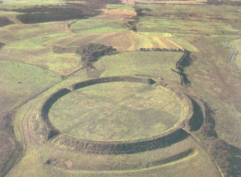
Fig 1 - A Trelleborg fortress today
The very phrase "Viking urban planning" may strike some as an oxymoron. The Vikings are famous for raiding, conquering, and pillaging, hardly activities that resonate with the the careful design and planning of cities. Yet a group of geometrical fortresses exhibiting exacting planning were built in Denmark by the Viking king Harald Bluetooth around A.D. 980, and these give us insights into cities and planning in the Viking age. Most of my discussion here is based on Roesdahl (1987), an excellent discussion of these fascinating sites.

Fig 2 - Plans of three Trelleborg sites
At least four of these fortresses are known. They are often referred to as the "Trelleborg fortresses," after the first one to be discovered and excavated. Figure 2 shows plans of three of these settlements. These sites are clearly planned; they correspond to both of the measures of urban planning for ancient cities: standardization among cities, and coordination of buildings within cities (Smith 2007). The main features they share are: outer circular walls  with ditches; with four gates at the compass points; two axial roads that link the gates; a ring-road inside the rampart; and large standardized long-houses arranged in quadrangles (Roesdahl, p.211). Within each site, the houses are identical in size and form.

Fig 3 - Reconstruction by Holger Schmidt of Firkat
Fig 4 - Reconstruction of a house
Based on artifact dating and dendrochronology, all of the Trelleborg fortress sites were built in or close to A.D. 980, and they were only used for a very short time. Although the housing at first glance looks like soldier's barracks, excavation shows that men, women, and children lived in the sites, and that some were craftsmen. Roesdahl interprets these as "very special and very organized royal manors" (p. 217). Several reconstructions of the houses have been made (Fig. 4).

Fig 5 - Realm of Harald Bluetooth
King Harald Bluetooth ruled Denmark from around A.D. 958 - 985. His realm covered a sizable part of southern and western Scandinavia (figure 5). He was the first Viking king to convert to Christianity, and he set up elaborate rune stones at Jelling (fig. 6), in association with several large burial monuments. In case you were wondering, Harald Bluetooth provided the name for the Bluetooth wireless communication technology, developed by the Swedish company Ericsson. The Bluetooth logo consists of the runic characters for King Harald Bluetooth's name.

Fig 6 - Harald's runestone at Jelling
Fig 7 - Bluetooth runes
These circular fortresses are unique in Scandinavian urban history. They do not have clear predecessors or successors. In the interpretation of Else Roesdahl, they were built in a time of decline and crisis, "primarily to control a country ready to revolt." (p. 226). Within a few years, Harald's son, Sven Forkbeard, revolted, and Harald was killed in one of the resulting battles.


The Trelleborg fortresses are important as monuments of Harald Bluetooth's reign, and as a good example of the unusual practice of circular urban design (Smith 2007; Johnston 1983). But perhaps most importantly, their discovery and excavation overturned existing ideas of the urban accomplishments of the Vikings. In the words of Roesdahl,
[The discovery of] Trelleborg causes a sensation. Nobody had thought the barbaric Vikings able to plan, organise or construct such a sophisticated structure, and the learned world conseequently had to rethink their concept of Vikings. (p.208)

References


Brink, Stefan and Neil Price (editors)
2008    The Viking World. Routledge, New York.

Johnston, Norman J.
1983    Cities in the Round. University of Washington Press, Seattle.

Roesdahl, Else
1987    The Danish Geometrical Viking Fortresses and their Context. Anglo-Norman Studies 9:208-226.

Smith, Michael E.
2007    Form and Meaning in the Earliest Cities: A New Approach to Ancient Urban Planning. Journal of Planning History 6(1):3-47.


*** ONE of my favorite historical novels is The Long Ships by Frans Bengtsson, which starts with the end of Harald Bluetooth's reign and follows its Viking protagonists for several decades. According to a book review by NPR.org:   "Even though The Long Ships was first published in 1941, it remains the literary equivalent of an action-and intrigue-filled adventure movie that won't insult your intelligence...Bengtsson is an infectiously enthusiastic and surprisingly funny writer--even readers with zero interest in the Europe of a millennium ago will want to keep turning the pages." How can one not like a book whose characters have  names like Sven Forkbeard and Ragnar Hairy-Breeks?